

I did it, I did it, I did it!
I really needed this week off, like more than I could explain and I really don't even want to go back to those feelings. I decided if I was going to cash in all of my remaining time off I would need to use some for myself. I asked Gramma if the girls could sleep over her house Wednesday night so I could leave at 6am to head back to the Squam Lake area and do the Percival-Morgan loop. I investigated it beforehand and it looked fun and a bit challenging. It had caves, cliffs and ladders and was just a bit on the long side for me at 5.6 miles.
My plan was to go to the Squam Lake Association office to acquire a paper map. I had a photo of a map and was going to use this new GPS mapping app but I always try to back that up with paper. Awesomely enough, the store was empty. No employee to be found all though I walked into an open door and the hiking map shelf-empty.
I stopped at a local market and inquired and she said she didn't yet as it was their first day open for the year but she could answer any hiking questions I had. Mostly I wanted to know about ice which she informed me was gone in this area and the mud had dried up too. Happy Hiking!
I had also heard this was a pretty popular trail and well marked so I decided to just head out.
I parked in the Morgan lot and walked .3 miles down the road to the Percival trail head and started up.
Yellow Blaze was all I needed to know.
There were also large signs at trail crossings so really no way to mess this up and I kept checking the GPS which was working fine even on airplane mode.

Today's hike was happily stress free. I stopped to listen and attempt to spot a woodpecker hard at work, crossed many small brooks like this one and took a picture of the only flower I saw all day.

As my heart rate increased and I broke out in a sweat I periodically stopped and turned around. Little by slow the view got better. This is one of the advantages of hiking in all seasons. In Summer I would most likely be seeing beautiful foliage and no lake.


At this point a better map would have been helpful but nothing beat bumping into another hiker. (my first of the day actually) I asked which way and she said the caves were her favorite but she had her dog so she went the cliff route.
So left it is.
From this point on I am not sure if the pictures make sense but I will try to explain. This next picture is in fact the trail. That long piece of rock in the center is where I hooked a right into the cave opening.


I had to take off my pack and stick it into the opening as it wasn't big enough for all of me. I then sat uphill and put my feet into the cave first. I relate this type of hiking like a game of Tetris. Where is my foot going to go next? I love it like that.
One of the weirdest things was the feeling of ice cold air pouring out of the cave opening.
Once in the cave I took photos looking forward, back and forth.
This next picture is heading into the tunnel.

This is looking to my right. Not an exit but a place for sun to stream in.
This is looking back the way I came in.


This is the exit from the outside. I had to pretty much put my pack out but not lose it into a deep crevice of ice and shimmy under this dragon tooth of rock. The only issue was the ice. Not slipping on the slick ice which was in the sunlight was tricky. I had taken my ice spikes out when I got the no ice report but luckily the ice was over in 6 ft or so in only a couple places.

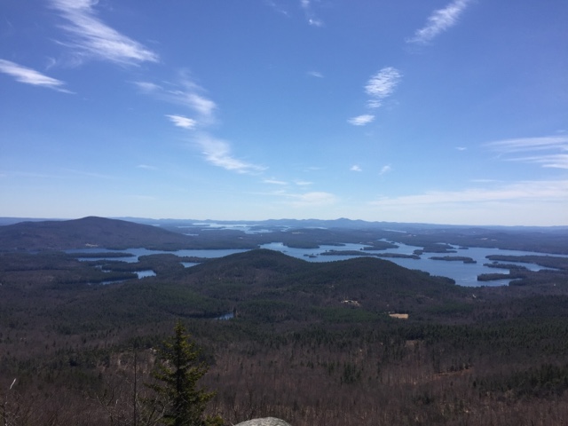
Now can we talk Summit?
Oh My, this is the view of Squam Lake and Lake Winnipesauke in the far background.
This was the approach to the Summit of Mount Percival.

People really are jerks sometimes. Don't they know geeks like me are walking all over this Summit looking for photo opps of our journey. Sadly this sign damage is fairly new as I have seen recent pictures and videos and the sign was complete.


At this point you can head down or head up to the Summit and continue on to other peak in the Squam Range. I decided to head to my second Summit and check out the ladders.

At Morgan's Summit I sat and ate with 2 other hikers. A woman with her 2 dogs and another with her 5 year old son. I knew I still had a couple miles to go so I decided to get back on my feet after a quick break. I made my way to the side with all bald rock and followed the yellow blaze painted on down. Again a map would have been helpful I think.
There aren't any pictures as concentration and hands needed to be focused on the job of not falling down the mountain. I soon found myself sitting on a rock with 2 sort of caves about 4-5 ft deep on either side of me. I began to get nervous. I couldn't figure out how to get down into them safely, I looked back the way I came and couldn't figure out going back up ( I had essentially slide down on my butt) and maybe sleeping here wouldn't be so bad.
I can hear voices below and 2 guys pop out of those caves on my right side. After explaining I am stuck and getting nervous one of them say give me your hand and walk down this rock in front of you.
Um. No. I will slide on my butt if you hold my hand. See over his shoulder was the cliff. I saw me tripping, and both of us going over the edge.
After many thanks I enter the cave and know my next step was to go down the ladders that I had hoped I would be going up. Sadly I could not do it. I couldn't figure out how to back out of the cave and slip down the 2 feet drop the first rung. I am not sure if it is clear in the picture but the top ladder is more like a V and no rung for the first 2 feet also at the bottom you must step left to the second ladder. I could not get a clear view of it from above and couldn't risk panicking on the ladder.

In the end I came back up and walked around the slabs of rock and back to the icy trail. I got to see this little guy dance around for a bit and took the picture of the ladders from the bottom when I came back around to the front of that cliff. I might have been able to do it going up as I wouldn't look back but down was a no for me.


This trail was a longer and more gradual decent and had some cool sights.


By the time I was back at the car I had a total of 7 miles under my belt and I felt great both physically and mentally. Bring on Mount Washington.

1 comment:
Great report! Well done, FB.
Post a Comment